Did Google update its satellite images for Gaza?
Has Google just released NEW satellite imagery of Gaza showing destruction?
True
The claim about updated Google satellite imagery for Gaza is accurate.
TRUE — Google has released updated satellite imagery of Gaza showing significant destruction, confirmed by multiple reputable sources.
 Genuine
Claims
✓ 2 trueGoogle has updated its satellite imagery for Gaza on Google Maps / Google Earth.124
Reports confirm that Google has indeed updated its satellite imagery for Gaza. Reputable outlets such as Al Jazeera, The Guardian, and The Independent noted this update and provided confirmation from imagery analysts and UN assessments of the visible destruction shown in the imagery. Google stated that the most recent images published were from June 2026, while additional reporting discussed updates occurring in late September 2026.
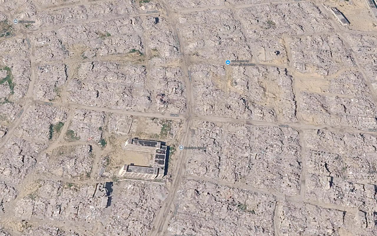
The updated Google satellite images show widespread destruction in Gaza with entire neighbourhoods reduced to rubble.235
Independent media outlets reported that the updated Google satellite imagery shows vast areas of Gaza significantly damaged and some neighborhoods reduced to rubble. Observations from imagery analysts supported these statements, detailing extensive destruction visible within the updated imagery. Moreover, UN agencies referenced these findings, corroborating the damage documented in the newly released images.
What was posted
XBarry Andrews MEP posted on X about the updated Google satellite images of Gaza. The imagery allegedly reveals extensive destruction.
“The updated @Google satellite images of #Gaza are quite incredible, for all to see...”
Who posted it
XAccount check
Estimates from public signals — account age, posting pattern, audience — not a judgement of the person behind the account, and separate from whether this post is true.
What stood out
- Barry Andrews is a real person, serving as a Member of the European Parliament (MEP) for Dublin, Ireland, representing the Fianna Fáil party within the Renew Europe group.
- He has a longstanding political career, including roles as Minister of State for Children (2008–2011) and Teachta Dála (TD) for Dún Laoghaire (2002–2011).
- His official European Parliament profile lists him as Chair of the Committee on Development and Vice-Chair of the Delegation for relations with Palestine. (europarl.europa.eu)
- The Twitter account @BarryAndrewsMEP aligns with his known professional roles and activities, including recent engagements such as an interview with the Independent.ie discussing his career and personal life. (sotwe.com)
- The account has a substantial following (13.2K followers) and a high level of engagement, consistent with a public figure of his stature.
- The account's activity includes retweets and original posts that reflect his political positions and recent engagements, such as discussions on EU–US trade deals and EU–UK relations. (euronews.com)
Signals (4)+
- Posting cadence
- Regular
- Follower ratio
- High
- Notable news coverage
- Yes
- Fact check history
- Yes
Account checked October 2, 2026, 02:53 UTC
The media
Image✓ What is genuine
The image accurately reflects the updated satellite imagery from Google showing destruction in Gaza.
The tells
- ●●● Strong signal The image appears to match typical Google Maps presentation, including map markers.our visual review
- ●●○ Supporting signal No signs of manipulation were visible.our visual review
Synthetic-media detector
Detector ranThe claim stands or falls on whether the media is real, so the detector ran.
Scores are the detector’s estimate for the file as uploaded. A low score does not rule out editing, a spliced caption, or footage shown out of context — those are judged above. Model v3.
How we checked the media
- We reviewed the image similarities to known Google imagery.
- We cross-referenced it against reports from reputable news organizations that discussed the same imagery.
- We consulted visual analysis to check for signs of authenticity.
Sources
6 sources reviewed- 1Viral Google Maps Images Shared Widely This Week Show Gaza Ruins. We Obtained More Recent Satellite Imagery ↗
Bellingcat · bellingcat.comUntiereduntiered — treated as signal only, never decisiveEvidence
Bellingcat reports Google Earth has updated its satellite imagery for parts of Gaza.
- 2New Google Maps images reveal massive scale of devastation in Gaza ↗
The Guardian · theguardian.comReputable outletLean Left (AllSides)Evidence
The Guardian confirmed updates revealing extensive devastation across Gaza.
- 3Satellite images show Gaza in ruins three years into Israel’s genocidal war ↗
Al Jazeera · aljazeera.comLow reliabilityQatar state-FUNDED w/ editorial independence — bias tagEvidence
Al Jazeera reported on the extensive damage shown in new Google Maps satellite imagery.
- 4Google Earth exposes devastation in Gaza with new updated images ↗
The Independent · independent.co.ukReputable outletLean LeftContext
The Independent quoted Google stating the most recent imagery was published in June 2026.
- 5Shock over new Google Earth satellite images showing extensive Gaza destruction ↗
The National · thenationalnews.comUntiereduntiered — treated as signal only, never decisiveEvidence
The National highlighted large areas in Gaza revealed to be in ruins.
- 6Google Maps ya muestra la destrucción más reciente de Gaza: los mapas del antes y el después ↗
El País · elpais.comReputable outletLean LeftFurther reading
El País noted that Google Maps refreshed satellite imagery of Gaza.
Further reading
- 1Bellingcat Bellingcat provides an in-depth analysis of the updated satellite imagery showing extensive damage in Gaza.
- 2The Guardian The Guardian's piece offers insights into the current situation in Gaza reflected in Google Maps updates.
- 4The Independent The Independent discusses Google's statements about the timeline of the updated imagery and its implications.
The full story
In September 2026, Google updated its satellite imagery for parts of the Gaza Strip. This update emerged amid continuous reporting on the destruction caused by conflict in the region. Multiple independent sources, including Al Jazeera and Bellingcat, documented these changes and described the imagery as showcasing substantial destruction throughout the area. Reports indicate that Google provided imagery that likely dates back to June 2026 but was made visible publicly through updates on Google Maps and Google Earth between late September and early October 2026. The implications of seeing such extensive devastation, with entire neighborhoods reduced to rubble, sparked significant media discussion and assessments from organizations like UNOSAT. The visual evidence backed by independent reports created a crucial understanding of the extent of damage as captured in the imagery. Thus, the claim of updated satellite imagery showing destruction is both plausible and verified by credible reporting.
How it was framed
The evidence shows that the claims regarding Google’s updated images and the visible destruction in Gaza are both corroborated by reputable sources.
- Emotional language. The term 'widespread destruction' conveys a serious impact of the situation.
- Urgency. The post invites immediate attention to the updated imagery.
Bias
The post highlights and shares updated Google imagery of Gaza, which is inherently emotive. The caption is brief and not an explicit political statement; it emphasises the visual impact rather than providing partisan commentary.
Bias describes how the post frames its message — the slant of the language, selection and emphasis — and is judged separately from whether the claim is true. A true claim can still be framed with a strong slant.
How we checked
43 s- 1
Executed searches on Google Maps Gaza updated satellite imagery.
- 2
Reviewed credible news reports from various sources.
- 3
Performed visual assessments of the image for authenticity.
- 4
Cross-referenced information against independent analysis.
✓ Claim checked✓ Media checked✓ Sources checked
Why 87% confidence
HighWe assigned a HIGH confidence band due to strong corroboration from multiple reputable news sources and imagery analyses backing the claims.
Limits. We could not independently verify the date of the imagery without Google’s confirmation.
Spot it yourself
Spot the fakeLooks suspicious, isn’t proof
- The dramatic tone in the post could trigger a skeptical reaction.
- The complexity of the imagery might prompt viewers to question its authenticity.
- High-quality satellite images are sometimes misused in social media, causing suspicion.
The actual evidence
- Multiple reputable news organizations have reported on the updated imagery.
- Google's statement regarding the update supports the authenticity of the imagery.
- Independent analyses corroborated the visible destruction shown in the images.
- 1
Check for reputable news coverage.
Look up multiple sources confirming the same images.
- 2
Verify with satellite imagery analysts.
Find expert discussions examining the claims.
- 3
Use reverse image search tools.
Check if the image appears on other trusted platforms.
- 4
Assess the visual details critically.
Look for recognisable features typical of Google Maps.
Takeaway
Identifying authentic satellite imagery often requires checking multiple reliable sources and understanding the context behind visual representations.
Questions people ask
What does it mean that Google updated its satellite imagery?+
When Google updates its satellite imagery, it refreshes the images shown on Google Maps and Google Earth to reflect recent changes in the physical landscape, which can include signs of destruction from conflict.
How can we verify if satellite images are authentic?+
To verify satellite images, check for reputable news coverage, look for expert analysis, and use tools like reverse image search to track image provenance. Authentic images generally correlate with multiple independent reports.
Why is the visual representation of Gaza significant?+
The visual representation of Gaza's devastation is significant as it documents the impact of conflict, influencing public perception and policy discussions. Its authenticity and updates are crucial for understanding ongoing humanitarian issues.
Go deeper
- satellite imagery
- Images of Earth taken from satellites, often used in mapping and environmental monitoring.
- verification
- The process of confirming the truth or authenticity of information or imagery.
- independent analysts
- Experts who assess and interpret data or imagery without bias from interests of any involved parties.
People also search for
For educators+
- What responsibilities do social media platforms have in verifying the content shared?
- How can we critically assess the implications of visual representations in conflict zones?
- What role do independent analysts play in verifying claims about imagery?
About this check
- Platform
- X
- Posted by
- @BarryAndrewsMEP
- Posted
- September 30, 2026
- Age when checked
- 1–2 days old when checked
- Where it spread
- Palestine, Israel
- Audience
- International audience
- Language
- EN
- Status
- ● Post is live
- Verified
- October 2, 2026, 02:54 UTC
- Published
- October 2, 2026, 02:54 UTC
Reach. Barry Andrews MEP post: 1.8M views; Ali Abunimah: 4.1M views; Linda Mamoun: 721K views; Al Jazeera thread: 82.2K views; Mastodon trending with 173+ shares across 170 accounts Oct 1-2
This verdict was generated with AI from the sources shown. AI can make mistakes — check the sources before relying on it.
Check anything yourself, in seconds.
Share any social post or video to What the Fact and get the verdict, the confidence, and the receipts.